20 Years of Climate Change in California
Soorya Narayan Satheesh & Wadzanai Makomva
Introduction
Climate change is one of the most pressing issues of our time with its impacts being felt around the world. In California, the effects of climate change are particularly acute, with changes in temperature and precipitation having a significant impact on ecosystems, communities, and the economy. We believe that understanding the relationship between climate change and changes in physical systems such as temperature and precipitation is essential for developing effective strategies to mitigate and adapt to these impacts. Over the past century, California has experienced significant changes in temperature, with average temperatures rising by about 2.5 degrees Fahrenheit . This increase in temperature has led to more frequent and severe heat waves, longer and more intense wildfire seasons, and other impacts on the state's ecosystems and communities. Changes in precipitation patterns have also affected California, with the state experiencing more frequent droughts and floods.
Changes in Temperature
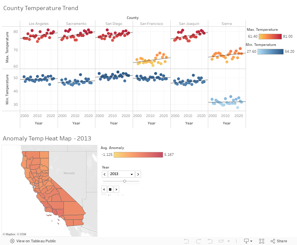
Unusually hot or cold temperatures are reported to result in prolonged extreme weather events such as summer heat waves or winter cold spells. Prolonged exposure to excessive heat and cold can damage crops and injure or kill livestock or lead to wildfires. Record-setting daily temperatures, heat waves, and cold spells are believed to be natural part of day-to-day variation in weather; however, as the Earth’s climate warms up, heat waves are expected to become even more frequent and intense. Conversely, cold spells are expected to decrease. In most locations, scientists expect daily minimum temperatures—which typically occur at night—to become warmer at a faster rate than daily maximum temperatures. This change will provide less opportunity to cool off and recover from daytime heat. We take a closer look at 6 California counties that are known to experience extreme temperatures. For the purposes of our exercise we wanted to assess the validity of these claims and results charts below show an upward trend in maximum temperatures and a relatively slower decrease in minimum temperatures as reported.
Changes in Precipitation
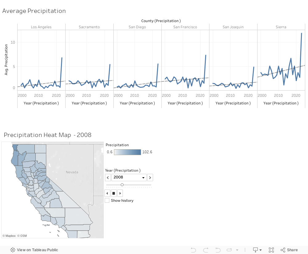
As average temperatures increase and result in even more evaporation, some (but not all) states are witnessing a gradual increase in overall precipitation. We observe that a warming climate is predicted to result in increased precipitation in many areas within California. There is a general misconception that an increase in precipitation is a positive change however, Just as precipitation patterns vary across the world, however, so do the precipitation effects of climate change. By shifting the wind patterns and ocean currents that drive the world’s climate system, climate change will also cause some areas to experience decreased precipitation whilst others experience the opposite. Increases in heavy precipitation may not always lead to an increase in total precipitation over a season or over the year, because of this, we chose to analyze average yearly precipitation values over a 20 year period. With some climate models projecting a decrease in moderate rainfall and an increase in the length of dry periods, therefore offsetting the increased precipitation occurring during heavy events, the combination of more intense precipitation and an increased frequency of extreme events can lead to changes in overall precipitation levels.
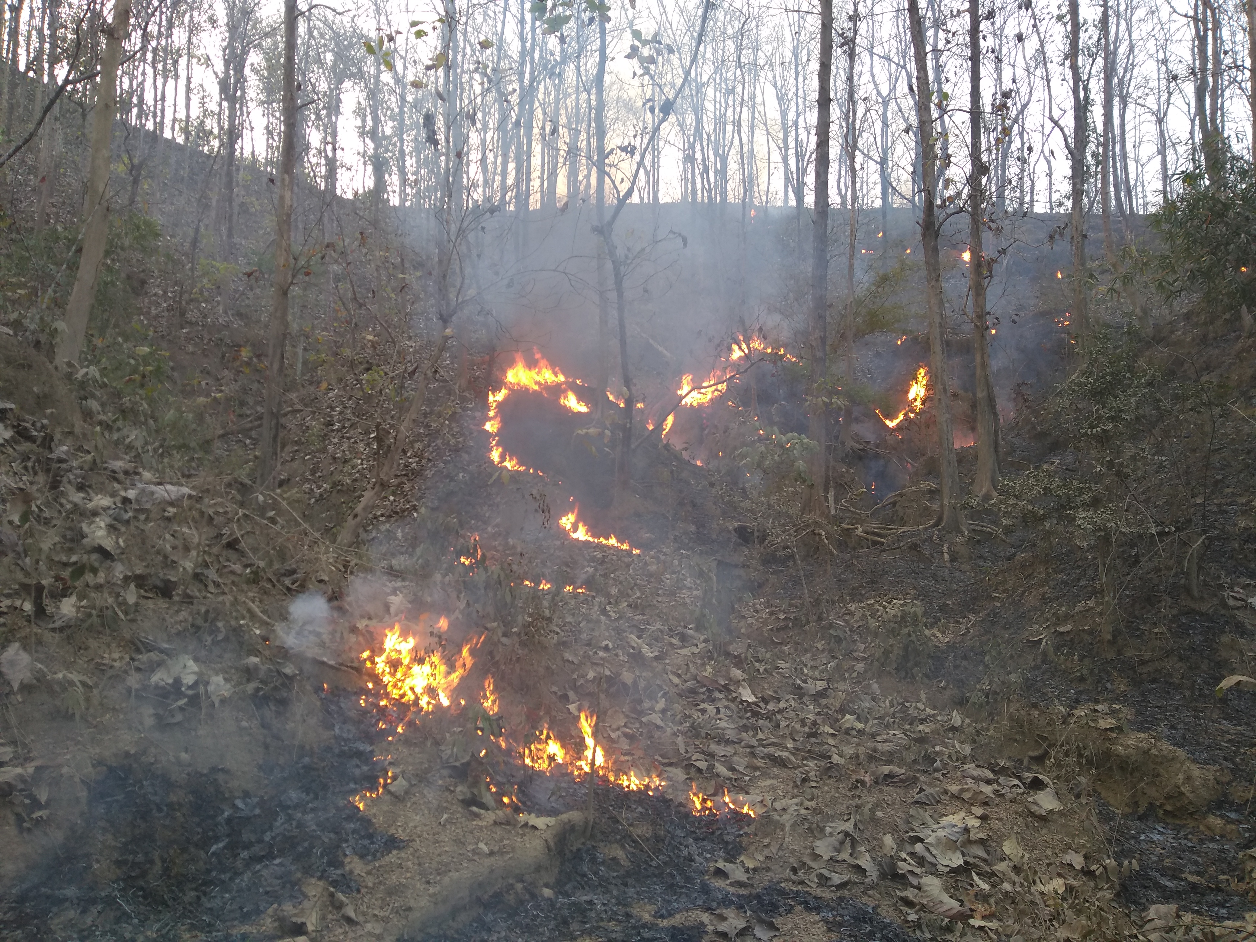
Wildfire in California
California has a long history of wildfires, but in recent years, the frequency and intensity of these fires have increased dramatically due to the effects of climate change. We have seen how California is experiencing hotter and drier conditions in the last several decades. The snow water content of the state declined from a high of 240% in 1952 to a low of 52% in 2012. The snow water content of the state directly affects the amount of water available in the different streams and rivers of the state. The higher temperatures lead to more evapotranspiration from the vegetation, leading to a water deficit. Water deficit conditions lead to the death of vegetation. Records show that from 2010 to 2021, over 170 million trees died. Every dead tree is likelier to catch fire than a healthy living tree. So the presence of millions of dead trees in the forests of California has increased the wildfire risk. Here we have analyzed the reports of wildfires from NASA's MODIS satellite from 2000 to 2020. The incidents of forest fires have steadily increased from 418 in 2000 to 49,827 in 2020. We also observed that the temporal distribution of forest fires shows more forest fires occurring during the summer months in most cases but also in winter months in others.
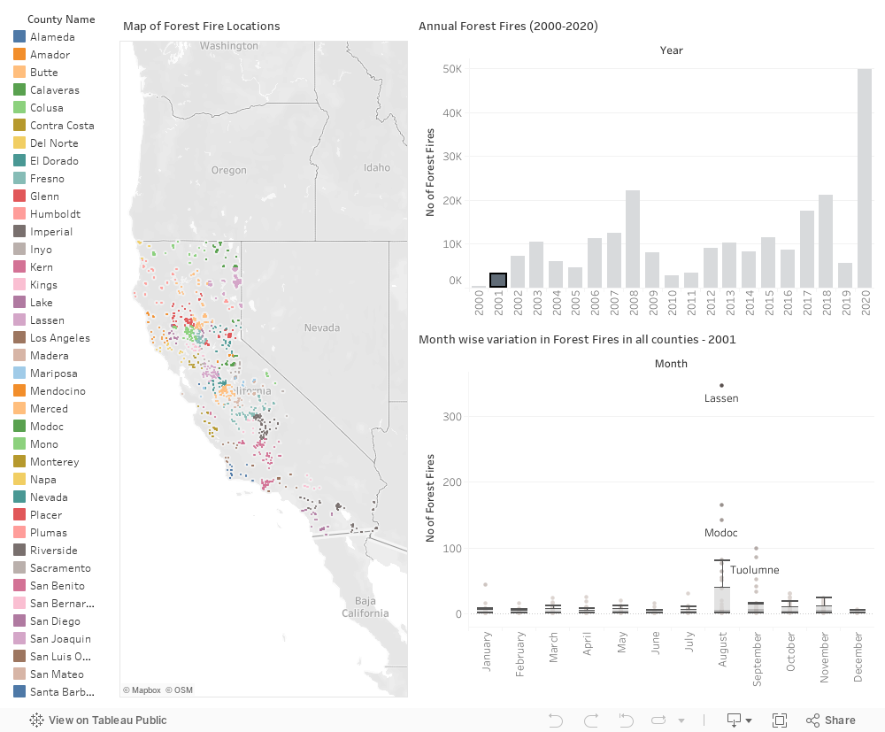
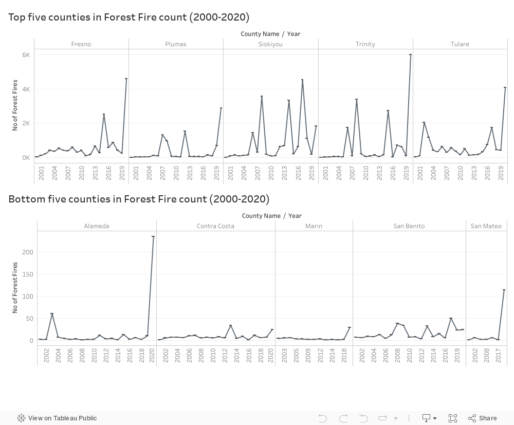
California has fifty-eight counties, and the impact of forest fires is not uniform. Understanding the spatial differences in the occurrence of forest fires is crucial for proper planning and allotment of key resources for tackling forest fires. Here we chose to focus on the five counties with the largest and smallest number of wildfires from 2000 to 2020. Out of the fifty-eight counties of California, the top five counties were Fresno, Plumas, Siskiyou, Trinity and Tulare. The distribution of wildfire occurrences is also unique for each of these counties. When we look at Fresno, we can see that it had relatively much fewer wildfires in 2000 compared to the 2019-20 period when it had over four thousand wildfire incidents. Trinity, Tulare and Plumas also show a similar pattern of the number of wildfires increasing towards the 2019-20 period. On the other hand, Siskiyou portrays a different picture, with more wildfires reported in 2017.
The lowest five counties in the wildfire reports are Alameda, Contra Costa, Marin, San Benito and San Mateo. Compared to the top five counties, the highest annual report of wildfires for the bottom five counties is Alameda having only 235 forest fires reported in 2020. In contrast, Trinity County reported close to 6000 wildfires in 2020. Out of the five counties, we can see that Marin County had the least prevalence of wildfires, with mostly only single-digit reports.
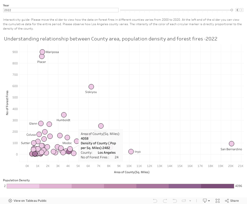
Wildfires disproportionately affect the communities that live on the fringes of forests, and they get significantly less reaction time, and many communities are devastated by wildfires. So, the population density of a county impacts the severity of the impact of wildfires in that county. In addition, we also need to understand the density of forest fires in the county and how forest fires affect counties with varying areas. We observed that more forest fires are mostly observed in counties with less population density and lesser areas. Only Los Angeles County, with its high population density, shows a different trend by having over 1300 wildfires in 2009.
Acknowledgments
- This research benefited from the support and services of UC Berkeley's Geospatial Innovation Facility (GIF), gif.berkeley.edu.
- We acknowledge the use of data and/or imagery from NASA's Fire Information for Resource Management System (FIRMS) (https://earthdata.nasa.gov/firms), part of NASA's Earth Observing System Data and Information System (EOSDIS).
- We acknowledge the use of information from NOAA website for this project https://www.ncei.noaa.gov/access/monitoring/climate-at-a-glance/county/time-series